
Company
- Home
- About us
Listings
- Summary of listings
- Elfrida Farm
- Dateland Tract-SOLD!
- Bouse Organic - SOLD!
- Taylor Dairy- SOLD!
- Benson Land- SOLD!
- Holbrook Ranch - SOLD!
- Greater AZ Farm - SOLD!
- Squaw Crk Ranch -SOLD!
- J&K Organic Farm -SOLD!
- White House Rnch- SOLD!
Services
- Brokerage
- Appraisals
- Site Selection/Assembly
- Market research
- Property Tax Analysis
- Water rights
- Mapping/GIS
Members
- Steve Pendleton
- Mack McKeon
Careers
- Appraisal & Real Estate
News
- Blog/RSS ![]()
- Member login
*** OFF THE MARKET ***
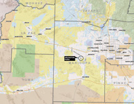
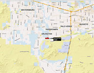
Arlington Farm
Maricopa County, Arizona
![]() Description, Location & Access
Description, Location & Access
The farm is located on the southwest of Buckeye Arizona within the Arlington Canal service area. The property is entirely south of the Arlington Canal east off of South 319th Ave.
 |
 |
Regional Map |
Neighborhood Map |
 |
 |
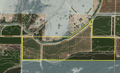
Aerial Map w/ soils |
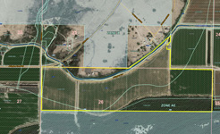
Aerial Map w/ flood |
![]() Land Tenure
Land Tenure
166.206 +/- gross deeded acres per county assessor records
![]() Legal Description
Legal Description
Portions of Sections 23 and 26 Township 1 South and Range 5 West, Maricopa County Arizona
Maricopa County Assessor Parcel Numbers
- 401-33-017A 74.038 AC +-
- 401-31-003H 9.6 AC +-
- 401-33-016 77 AC +-
- 401-31-003G 5.567AC ++
![]() Property Description
Property Description
The property is primarily irrigated farmland currently in alfalfa fields rented to a local farmer. A portion of the property is native desert consisting of thick mesquite and tamarisk brush. The property is served by the e Arlington Canal which adjoins the property. There are no buildings.
![]() Water
Water
Irrigation water is supplied by the Arlington Canal Company and has Grandfathered water rights on file with the Arizona Department of Water Resources (ADWR).
![]() Soils
Soils
The soil types are considered suitable for farming as the property is currently and has historically been utilized for standard field crops such as cotton, various grains, alfalfa and other hay crops. The Natural Resource Conservation Service (NRCS) has surveyed the area for soils and has found the following soil types:
- CF Carrizo and Brios Soils 1%
- Gh Gilman loan, saline alkali 51.9%
- Vh Vint fine sandy loam 1.7%
- Ao Avondale clay loam 0.7%
- Vg Vint loamy fine sand 1.8%
- Cn Cashion clay, saline – alkali 3.3%
- Vn Vint clay loam 4.7%
- Ap Avondale Clay Loam 30.0%
- Ge Gilman Fine sandy loam 0.005%
- Aa Agualt Loam 4.5%
- Vk Vint loam 0.4%
![]() Aggregate Potential
Aggregate Potential
The property has been explored for aggregate and drilling data is available upon request.
![]() Flood Zone
Flood Zone
The property includes the following zones:
Effective Floodplain: AE (Floodway) The floodway is the channel of a stream plus any adjacent floodplain areas that must be kept free of encroachment so that the 100-year flood can be carried without substantial increases in flood heights
Flood Zone AE: Base Flood Elevations determined. Special flood hazard areas subject to inundation by the 1% annual chance flood. The 1% annual chance flood (100-year flood), also known as the base flood, is the flood that has a 1% chance of being equaled or exceeded in any given year. approximately 90%
![]() Zoning
Zoning
The property is located in an unincorporated area of Maricopa County and is currently designated as R-43 which is a rural agricultural designation with a minimum lot size of one acre.
![]() Property Taxes
Property Taxes
2018 $2,073.78
![]() Disclosure
Disclosure
One of the Owners is an Arizona Licensed Real-estate Agent.
![]() Price
Price
$1,700,000.00 – Cash
![]() Downloadable brochure
Downloadable brochure
Please click here for a PDF brochure.
![]() Contact
Contact
Mack McKeon
Southwestern Agricultural Services
7254 E Southern Ave, #107
Mesa, AZ 85209
(480) 539-2671
Email: wdmckeon@spireco.com